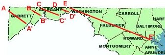
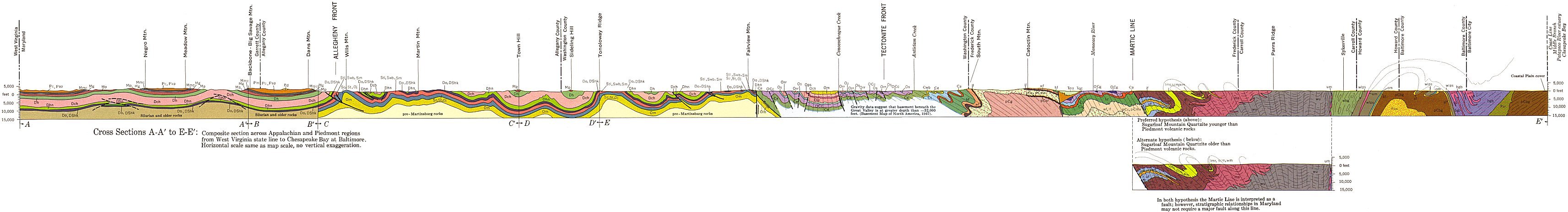
| Appalachian and Piedmont Regions (1968) |
| Geologic Cross Sections Index(1968) |
 |
PLEASE NOTE: These images were scanned from a paper copy of the 1968 Geologic Map of Maryland. Due to the age of this map, these images do not necessarily represent an accurate interpretation of currently accepted geologic theory. Also, the projection of the original map was distorted during reproduction, and the paper medium is not stable. Therefore geographic or Cartesian coordinates cannot be applied to these images, and georeferencing is not possible.
These images are for illustration purposes only. Do not use these documents for GIS, navigation, legal purposes, surveying, or anything else other than document illustrations. They were created only to illustrate our publications and are not accurate enough to be used for any other purposes. You may use them as illustrations only, and you must give proper credit to Maryland Geological Survey when using these maps.
You need a large-format printer to print this image. It will not fit on a regular printer page.
|
Legend |
|||||||||||||||||||||||||||||
 |
|||||||||||||||||||||||||||||
 |
 |
||||||||||||||||||||||||||||
 |
 |
 |
|||||||||||||||||||||||||||
Use your browser's SAVE feature to save this map. Place your mouse over the map and click your RIGHT mouse button (or the Left button if you have set up your mouse as a left-handed mouse). A pop-up menu will appear. Select "Save image as.." (Netscape) or "Save picture as.." (IE) and type in a name for the map in the FILE NAME dialog box. Once saved, you can resize this image with your favorite graphics software.
Updated
4/10/08